FRIDAY april 27th
401 south rogers
free!  7pm
a photo show by jeremy hogan
all prints $10, framed.
also, a premiere screening of his video of last year’s plan-it-x festival…..
FRIDAY april 27th
401 south rogers
free!  7pm
a photo show by jeremy hogan
all prints $10, framed.
also, a premiere screening of his video of last year’s plan-it-x festival…..
MONDAY april 9th
at 401 south rogers
8:30pm  $3-5 suggested donation
BLUE SHIFT (solo violin from providence, ri)
D.B.H.
HOT FIGHTER #1
Cheap vegan breakfast featuring tofu scrambler w/ veggies, tempeh bacon, fried potatos, toast, + more.
hey y'all!  come help make prom decorations so we can make the
bluebird look sweeeet!  this is the biggest fundraiser of the year for
both boxcar and pages, so we really need your help!

details-
- 4pm on sunday (we'll go for hours, so show up whenever you can)
- sparky's house/microcosm headquarters (north-west corner of 3rd & rogers)
- bring any craft supplies you have (paint, markers, paper, cardboard,
tape...)

we are also building a decorating committee for the day of the prom.
decorating starts at noon on saturday the 7th.  if you're into it,
please e-mail me or sign up at boxcar.  yeah!

abbey
boxcarbooks.org, bloomingtonarts.info, http://events.publicbroadcasting.net/wfiu/events.eventsmain, http://www.visitbloomington.com/calendar/, and http://events.iu.edu/webevent.cgi?cmd=opencal&cal=cal3
Update 2010-10-17: It seems like a lot of people come to this post looking for a blank map of the United States. I updated the link at the bottom of the page to point to a much better version from Wikimedia Commons. Download a SVG/PNG blank map of the United States.
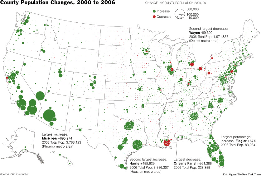
This map has been on my mind all week. It’s from a NYTimes article titled Census Reports Arizona County Still Has Biggest Growth (though the article isn’t just about AZ). It’s a map of relative population increases/decreases around the country. Looking at the map, I want to think in terms of cities or communities as winners or losers or to think about how different or disconnected cities across the country are from each other. But what if this initial perception continues to shape my attitudes, or my actions? What happens when this mentality moves from the individual to the cultural or plays out at a policy level? It seems pretty unimaginative or limiting. This made me think, is there a way of looking at the USA, taking into account factors other than population growth, or incomes, or all the usual metrics of cities and communities? Is there a way of thinking that would show New Orleans as a big green dot and Atlanta as a big red dot? Is there a representation of qualities of cities that would make both New Orleans and Atlanta have the same type of dot? Is the red/green dot dichotomy too limiting to begin with? Let’s make our own maps that maybe show the relative nature of the places we live, or know, or read about, or hear about from a different perspective, with different values or metrics, or with more imagination.
Here’s how:
Info on bands:
I think most of them have records available at Sweet Hickory.
This is the command that I used to make a 4up (that would be four equally sized images on one page) layout on letter sized paper of a tabloid sized poster. I used the excellent Multivalent tool’s Impose feature.
C:\Documents and Settings\surplus\Desktop>java -Xms32m -Xmx256m -classpath “C:\Documents and Settings\surplus\Desktop\Multivalent20060102.jar” tool.pdf.Impose -nup 4 -dim 2×2 -paper letter -page 1,1,1,1 promposter.pdf
Update:
This is the command that I use on my notebook running Ubuntu Gutsy Gibbon:
/usr/lib/jvm/java-6-sun/bin/java -classpath /home/ghing/java/Multivalent.jar tool.pdf.Impose -nup 4 -dim 2x2 -paper letter -page 1,1,1,1 describe_yourself.pdf